

Boracay
Boracay is a
small island in the Philippines located approximately 315 km (196 mi) south of
Manila and 2 km off the northwest tip of Panay Island in the Western Visayas
region of the Philippines. Boracay Island and its beaches have received awards
from numerous travel publications and agencies. The island comprises the
barangays of Manoc-Manoc, Balabag, and Yapak municipality of Malay, province of
Aklan. The island is administered by the Philippine Tourism Authority and the
provincial government of Aklan. Apart from its white sand beaches, Boracay is
also famous for being one of the world's top destinations for relaxation. It is
also emerging among the top destinations for tranquility and nightlife.
Puerto
Princesa, Palawan
Puerto Princesa is a city located in the
western provincial island of Palawan, Philippines. Though the provincial seat
of government for Palawan, the city itself is one of 38 independent cities
within the Philippines not controlled by the province in which it is geographically
located and is therefore an independent area located within Palawan.
As of 2010, Puerto Princesa had a
population of 222,673 people, making it the least densely populated city in the
Philippines. In terms of land area, the city is the second largest
geographically after Davao City with an area of 2,381.02 square kilometres
(919.32 sq mi).Puerto Princesa is the location of the Philippines's Western
Command headquarters.
Today, Puerto Princesa is a popular
tourist city with many beach resorts and seafood restaurants. It has been
acclaimed several times as the cleanest and greenest city in the Philippines.

Baguio
City
The City of Baguio is a highly urbanized
city located in the province of Benguet in northern Luzon Island of the
Philippines. The city has become the center of business and commerce as well as
the center of education in the entire Northern Luzon thereby becoming the seat
of government of the Cordillera Administrative Region (C.A.R.).[3] According to
the 2010 census, Baguio City has a population of 318,676.
Baguio City was established by the
Americans in 1900 at the site of an Ibaloi village known as Kafagway. The name
of the city is derived from the word bagiw in Ibaloi, the indigenous language
of the Benguet Region, meaning 'moss'. The city is at an altitude of
approximately 1450 meters (4760 feet) in the Luzon tropical pine forests
ecoregion conducive to the growth of mossy plants and orchids.
Because of its altitude, Baguio City was
designated by the Philippine Commission as the Summer Capital of the
Philippines on June 1, 1903. It was incorporated as a chartered city by the
Philippine Assembly on September 1, 1909, as authored by former Philippines
Supreme Court Justice George A. Malcolm. The City of Baguio celebrated its
Centennial on September 1, 2009.

Vigan
Vigan, with its centuries-old edifices,
is a breathing reminder of what was once a royal city.
One of the earliest Spanish settlements
in the country, Vigan was founded in 1572 by Juan de Salcedo who patterned its
design to that of Intramuros (Old Manila). It became the seat of the
Archdiocese of Nueva Segovia and was called Ciudad Fernandina in honor of King
Ferdinand.
Today, Vigan retains much of the patina
of 18th century Castillan architecture as seen in some 150 stone houses which
stand in the town's Mestizo District, notably Mena Crisologo Street. Many of
these ancestral homes are still in good condition and some have been turned
into cozy inns, museums, and souvenir shops.

Hundred Islands National Park
The Hundred Islands National Park is a
national park in the Republic of the Philippines. The protected area is located
in the city of Alaminos, in the province of Pangasinan in northern Philippines.
The islands, totaling 124 at low tide and 123 at high tide, are scattered in
Lingayen Gulf covering an area of 16.76 square kilometres (6.47 sq mi). Only
three of them have been developed for tourism: Governor Island, Quezon Island,
and Children's Island. The Lucap wharf in Alaminos, the entrance to the
National Park, is about 240 kilometres (150 mi) north of Manila, the capital of
the Philippines.

Banaue Rice Terraces
The Banaue Rice Terraces (Filipino:
Hagdan-hagdang Palayan ng Banawe) are 2,000-year-old terraces that were carved
into the mountains of Ifugao in the Philippines by ancestors of the indigenous
people. The Rice Terraces are commonly referred to by Filipinos as the
"Eighth Wonder of the World".It is commonly thought that the terraces
were built with minimal equipment, largely by hand. The terraces are located
approximately 1500 metres (5000 ft) above sea level and cover 10,360 square
kilometres (about 6000 square miles) of mountainside. They are fed by an
ancient irrigation system from the rainforests above the terraces. It is said
that if the steps were put end to end, it would encircle half the globe.
Locals to this day still plant rice and
vegetables on the terraces, although more and younger Ifugaos do not find
farming appealing, often opting for the more lucrative hospitality industry
generated by the terraces [citation needed]. The result is the gradual erosion
of the characteristic "steps", which need constant reconstruction and
care. In 2010, a further problem was drought, with the terraces drying up
completely in March of that year.

Chocolate Hills, Bohol
The Chocolate Hills is a geological formation in Bohol
Province, Philippines. There are at least 1,260 hills but there may be as many
as 1,776 hills spread over an area of more than 50 square kilometers (20 sq.
mi).They are covered in green grass that turns brown (like chocolate) during the
dry season, hence the name.
The Chocolate Hills is a famous tourist attraction of
Bohol. They are featured in the provincial flag and seal to symbolize the
abundance of natural attractions in the province. They are in the Philippine
Tourism Authority's list of tourist destinations in the Philippines they have
been declared the country's third National Geological Monument and proposed for
inclusion in the UNESCO World Heritage List

Ilocos Norte
Ilocos Norte is a province of the Philippines located in the Ilocos
Region. Its capital is Laoag City and is located at the northwest corner of
Luzon Island, bordering Cagayan and Apayao to the east, and Abra and Ilocos Sur
to the south. Ilocos Norte faces the South China Sea to the west and the Luzon
Strait to the north.
Ilocos Norte is noted for being the birthplace of former President
Ferdinand E. Marcos, who led an authoritarian rule over the country during the
latter half of his incumbency. The Marcoses enjoy a modicum of popularity in
the province. Ilocos Norte is also known as a northern tourist destination,
being the location of Fort Ilocandia, an upper class hotel and beach resort
famous among expatriates, and Pagudpud.

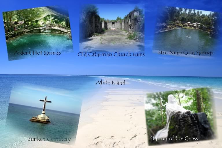
Camiguin
Camiguin (Tagalog pronunciation: [kamiˈɡin], (Cebuano: Lalawigan sa Camiguin), (Tagalog:
Lalawigan ng Camiguin) is an island province of the Philippines located in the
Bohol Sea, about 10 kilometres (6.2 mi) off the northern coast of Mindanao. It
is politically part of the Northern Mindanao Region of the country and formerly
a part of Misamis Oriental province. Camiguin is the second-smallest in the
country both in population and land area after Batanes.[3] Mambajao is the
capital of the province and its largest municipality both in area and
population.
The province
consists primarily of Camiguin Island, as well as a few other surrounding minor
islets including:
White
Island, about 5 kilometres (3.1 mi) west of the town of Mambajao
Mantigue Island, about 14 kilometres (8.7 mi)
south of Mambajao.
Negros Oriental
Negros Oriental, also called Oriental
Negros or "Eastern Negros", is a province of the Philippines located
in the Central Visayas region. It occupies the south-eastern half of the island
of Negros, with Negros Occidental comprising the north-western half. It also
includes Apo Island — a popular dive site for both local and foreign tourists.
Negros Oriental faces Cebu to the east across the Tañon Strait and Siquijor to
the south east. The primary spoken language is Cebuano, and the predominant
religious denomination is Roman Catholicism. Dumaguete City is the capital,
seat of government, and most populous city.

No comments:
Post a Comment